- Printed on Regular Paper (32lb)
- USGS topographic map of Christiansburg, VA, at 1:125000 scale. High-quality paper print. Perfect for wall maps.
- Cities, towns, villages: Ellett,Mason Cove,Airpoint,Farmington,Mountain Heights,Deep Dell,Oak Park,Hidden Acres,Hickory Hill,King,Westchester Court,Sunset Village,Kings Forest,Linkous,Beverly Heights,Hanging Rock,Poages Mill Estates,Ridgewood Park,Victory Heights,Atkinson Acres,Westward Lake Estates,Rogers,Hethwood,Sherwood Forest,The Orchard,Glenvar,Berryfield,Heidelberg Estates,Alleghany Addition,Canterbury Park,Windsor Court,Braeburn,Laurel Woods,Vermont Heights,Penn Forest,Laurel Ridge
- Rivers, creeks: Pine Branch,Spring Branch,Roaring Run,Cedar Run,Broad Run,War Spur Branch,Crosier Branch,Mason Creek,Craig Branch,Flatwoods Branch,Little Camp Creek,North Fork Potts Creek,Double Branch,Mill Creek,Flat Run,Georges Run,Camp Creek,South Fork Potts Creek,Dickey Farm Branch,Little Double Branch,Bee Branch,Porterfield Branch,Georges Swamp Branch,Indian Run,Indian Run,Gallion Branch,Pickles Branch,Callahan Branch,Purgatory Creek,Sweet Spring Run,Gish Branch,Green Creek
- Lakes: Rainbow Pond
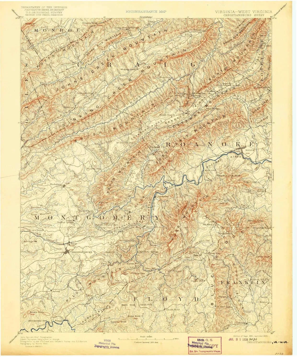
USGS topographic map of Christiansburg, Virginia, dated 1890, updated 1920.
Includes geographic coordinates (latitude and longitude), lines of elevation, bodies of water, roads, and more. This topo quad is suitable for recreational, outdoor uses, office applications, or wall map framing.
Printed on-demand by YellowMaps on the print material of your choice.
Shipping rolled from Minneapolis, MN, United States.
Product Number: USGS-5303800
Map Size: 20 inches high x 16.5 inches wide
Map Scale: 1:125000
Map Type: POD USGS Topographic Map
Map Series: HTMC
Map Version: Historical
Cell ID: 65201
Scan ID: 188899
Imprint Year: 1920
Survey Year: 1887
Datum: Unstated
Map Projection: Unstated
Map published by United States Geological Survey
Map Language: English
Scanner Resolution: 600 dpi
Map Cell Name: Christiansburg
Grid size: 30 X 30 Minute
Date on map: 1890
Geographical region: Virginia, United States
Northern map edge Latitude: 37.5°
Southern map edge Latitude: 37°
Western map edge Longitude: -80.5°
Eastern map edge Longitude: -80°
Surrounding map sheets (copy & paste the Product No. in the search bar):
North: USGS-5680165,USGS-5303948,USGS-5303950,USGS-5660062,USGS-5415850
East: USGS-5638435,USGS-5304080,USGS-5304086,USGS-5296683,USGS-5304228
South: USGS-5302886,USGS-5296201
West: USGS-5303308,USGS-5303808,USGS-5303310,USGS-5303312,USGS-5303824
")
")


")
